
Pickensville Day Use Shelter (Aliceville Lake)
Campground · Fee not listed
Fast facts
- Cost
- Not listed. Check locally.
- Type
- Campground
- Phone
- 662-245-5500
- Coordinates
- 33.2269, -88.2832
- Last verified
- September 19, 2026

About this place
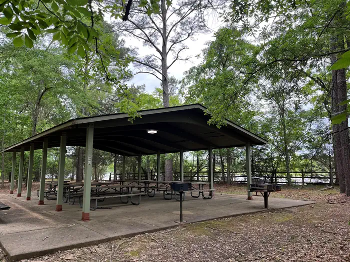
Overview Pickensville Day Use is situated in Pickensville, Alabama on Aliceville Lake along the Tennessee Tombigbee Waterway. The area features one shelter that can be rented. The area typically is open the beginning of March through the end of October. Pickensville Day Use is great for enjoying an afternoon lunch or fishing along the banks of the river. Recreation The Tennessee Tombigbee Waterway offers many recreational opportunities such as hunting, fishing, boating, and swimming. Hunting opportunities can be found on Corps of Engineers land in Mississippi and Alabama, as well as other state managed wildlife management areas along the waterway. Fishing the many varieties of fish on the waterway is a yearlong event, with people fishing along the shoreline or joining in on the many tournaments that are held on the waterway throughout the year. Boating is a popular activity on the waterway and many people enjoy waterskiing, swimming, and other water related activities. Swimming can be enjoyed from your boat or at a designated beach along the waterway. Facilities Each shelter provides water, electricity, and picnic tables for your use. A park host is available at most of the shelters where they can provide additional information if need be. Natural Features Pickensville Day Use has views of the main channel of the Tennessee Tombigbee Waterway where barges, yachts, and other recreational boats can be seen. It is a good spot to see fish jumping in the water and migratory birds fly overhead.
From the managing agency.
Is this site free?
We do not have a fee on record for this site. Confirm the cost locally before you go.
How do I get to this site?
this site is at 33.2269, -88.2832. We do not hold written directions for this one, so navigate to the coordinates.
Nearby
- PICKENSVILLE CG (PICKENSVILLE AL)0.4 mi
- Raleigh Ryan Ramp Picnic Shelter (Aliceville Lake)0.8 mi
- Tom Bevill East Bank Day Use (Aliceville Lake)1.4 mi
- Stennis East Bank Day Use (Columbus Lake)23.3 mi
- Waverly Day Use (Columbus Lake)26.6 mi
- DEWAYNE HAYES27.9 mi
- DeWayne Hayes Day Use (Columbus Lake)28.1 mi
- TOWN CREEK CAMPGROUND - WEST POINT - MS29.2 mi
No other services within 50 mi on the record.
SourceSource data is agency published. Last synced September 19, 2026. Community reports and photos are submitted by travelers and are not verified by the agency.
