
HOUSTON SHELTER
Campground · Fee
Fast facts
- Cost
- Fee charged
- Type
- Campground
- Phone
- 205-489-5111
- Coordinates
- 34.1244, -87.2981
- Last verified
- September 19, 2026
About this place
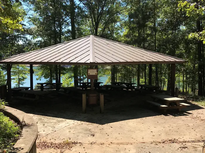
Overview Houston Shelter is a group picnic site nestled on the shore of Lake Lewis Smith in Bankhead National Forest. This is a popular recreation area offering a variety of activities. Shelter is first come first served. Site is walk-up only. Recreation Day users can enjoy a beautiful sand swimming beach. Other activities include motorized and non-motorized boating and water skiing. Anglers can fish for Kentucky Spotted Bass and Hybrid Striped Bass. There are also hiking trails in the area, including the 1.4 mile High Rock Loop and the nearly 2 mile Fox Run Loop. Facilities The picnic facility offers tables, flush toilets, grills and drinking water. A boat ramp and showers are nearby. Natural Features Bankhead National Forest is located in northwestern Alabama. The prominent feature of the area is the Sipsey Wilderness. Known as "The Land of a Thousand Waterfalls," the Sipsey Wilderness encompasses an area of abundant streams, old-growth forests, limestone bluffs and lush canyons. Lake Lewis Smith boasts more than 500 miles of shoreline marked by high rock bluffs. The water is clear and deep and provides excellent fishing.
From the managing agency.
Is HOUSTON SHELTER free?
No. HOUSTON SHELTER charges a fee.
How do I get to HOUSTON SHELTER?
HOUSTON SHELTER is at 34.1244, -87.2981. We do not hold written directions for this one, so navigate to the coordinates.
Nearby
- Houston Campground0.5 mi
- HOUSTON RECREATION AREA0.7 mi
- CORINTH RECREATION AREA1.8 mi
- Corinth Campground2.0 mi
- CLEAR CREEK (AL)7.3 mi
- Clear Creek Campground8.0 mi
- Mcdougle Hunt Camp15.0 mi
- BURCHFIELD BRANCH PARK47.4 mi
No other services within 50 mi on the record.
SourceSource data is agency published. Last synced September 19, 2026. Community reports and photos are submitted by travelers and are not verified by the agency.
